GATEHOUSE
The comprehensive gazetteer and bibliography of the medieval castles, fortifications and palaces of England, Wales, the Islands.
 
 
Home
The listings
Other Info
Books
Links
Downloads
Contact
 
Aglionby Platt Home
 
Print Page 
 
Next Record 
Previous Record 
Back to list 

The Gatehouse website record of

ye Thornwhase (Thorniewhats)

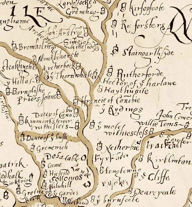
a location shown on a 1590 map of the West Marches of Scotland (The Aglionby Platt)

Also known as, or recorded in historical documents as; Thonytwaite

In the civil parish of Canonbie.
In the historic county of Dumfriesshire, Scotland.
Modern Authority of Dumfries And Galloway, Scotland.
1974 county of Dumfries and Galloway, Scotland.

OS Map Grid Reference: NY389784
Latitude 55.09684° Longitude -2.95754°

The given map reference is suggested as the probable location of ye Thornwhase shown on the Aglionby Platt.

There are no visible remains.

The likely form(s) of this building in 1590 are;

  • Pele House ('bastle').

A section of the 1590 Aglionby Platt. Image reproduced by permission of the National Library of Scotland
Reproduced by permission of the National Library of Scotland
Description

unlocated This tower, which is depicted on a map of 1590, cannot be located; the modern farmhouse of Nether Thorniewhats is at NY 389 784. (J and R Hyslop 1912; RCAHMS 1981)
Listed as tower. (RCAHMS 1997) (Canmore 101302)

(NY 3862 7821) Gilnockie Castle (NR) (Site of) OS 6" map (1957)
Earthworks which suggest a promontory fort of familiar type. (RCAHMS 1920)
The name 'Gilnockie Castle' seems to have been applied here because of the opinion held by some authorities, and disputed by others, that Johnnie Armstrong of Gilnockie had a tower at the E end of Gilnockie Bridge, possibly the predecessor of that noted on At the same time the Armstrong clan were responsible for the building of many of the border towers in the debatable lands, and on a small scale map of 1590 a tower is shown at 'ye Thornwhate'. Nether Thorniewhats is at NY 389 784. It is not known it there is any connection between 'ye Thornwhate' tower and the site E of Gilnockie Bridge. (J and R Hyslop 1912)
Situated on a promontory in a bend on the River Esk are the remains of a small fort measuring about 40.0m NE-SW by 36.0m transversley. It consists of a substantial earth and stone rampart with a causewayed entrance in the centre. The remaining sides are protected by the steep natural slopes to the river. The S side of the fort and the rampart and ditch have been mutilated by modern tracks and road. The interior has been quarried and there is no trace of any tower. The site is still known as 'Gilnockie Castle'. There is no trace of a tower at Nether Thorniewhats. Resurveyed at 1:2500. Visited by OS (RD) 21 December 1970
No change to the previous report. Visited by OS (JP) 20 February 1973
Gilnockie Castle: This medieval earthwork is situated on a promontory overlooking the River Esk at the E end of Gilnockie Bridge. A bank (7.5 m thick and 1.8m high) and external ditch cut off the neck of the promontory and defend an area measuring 61m by 36m. The interior has been extensively quarried and is crossed by the A7 public road. (RCAHMS 1981, visited December 1980)
Listed as earthwork (castle, possible). (RCAHMS 1997)
Scheduled as 'Gilnockie Castle, earthwork NE of Gilnockie Bridge... the remains of an earthwork, probably of later medieval date, surviving as a bank and ditch cutting off a prompntory in a bend of the River Esk (and) located in mature deciduous woodland.'(Information from Historic Scotland, scheduling document dated 26 March 2008)
Gilnockie Castle
Fort (NAT) OS (GIS) MasterMap, August 2009. (Canmore 67519)
Comments

The modern farmhouse at Thorniewhats is entirely consistent with the site as shown on the 1590 map (although that map is difficult to interpret and can be erroneous). However the map is clearly intended to show fortified houses in the West Marches. A site called Gilnockie Castle lies 450m SW of Nether Thorniewhats farmhouse.
The date of the earthworks at Gilnockie appears to be pre-historic. Despite it's obvious defensive quality there is no actual evidence of a late medieval dwelling here. It should be remembered that the main function of the marcher 'peles' (of all forms) was to be a farmhouse, the centre for agricultural activity and that defence was secondary to that activity. With the needs for animal and cart access considered it may be seen why actually prehistoric earthworks are actually rarely re-used.
The resident householder c. 1590.

1561 - Jamy Foster ("The names of the Greymes of Eske and Leven within the Countie of Cumberland gyven in by Richard Greyme of Netherbye to the Lorde Dacre, Warden of the West Marche of England" P.R.O. SP 59/9 ff. 197-203 (CSP For, 1561-62, no. 442), dated 23 August i 56 r)
- see Spence, R.T., 1980, 'The Graham Clans and Lands on the eve of the Jacobean Pacification' Transactions of the Cumberland and Westmorland Antiquarian and Archaeological Society Vol. 80 p. 92 online copy
Links to archaeological and architectural databases, mapping and other online resources

Data >
Canmore   County HER        
Maps >
Streetmap   NLS maps   Where's the path   Geology  
Air Photos > 
Bing Maps   Google Maps   Getmapping   Flashearth  
Photos >
Geograph   Flickr   Panoramio      

Sources of information, references and further reading
Most of the sites or buildings recorded in this web site are NOT open to the public and permission to visit a site must always be sought from the landowner or tenant.
It is an offence to disturb a Scheduled Monument without consent. It is a destruction of everyone's heritage to remove archaeological evidence from ANY site without proper recording and reporting.
Don't use metal detectors on historic sites without authorisation.
The information on this web page may be derived from information compiled by and/or copyright of Historic England, RCAHMS (or its successor Historic Environment Scotland), County Historic Environment Records and other individuals and organisations. All the sources given should be consulted to identify the original copyright holder and permission obtained from them before use of the information on this site for commercial purposes.
The author and compiler of Gatehouse does not receive any income from the site and funds it himself. The information within this site is provided freely for educational purposes only.
The bibliography owes much to various bibliographies produced by John Kenyon for the Council for British Archaeology, the Castle Studies Group and others.
Suggestions for finding online and/or hard copies of bibliographical sources can be seen at this link.
Minor archaeological investigations, such as watching brief reports, and some other 'grey' literature is most likely to be held by H.E.R.s but is often poorly referenced and is unlikely to be recorded here, or elsewhere, but some suggestions can be found here.
The possible site or monument is represented on maps as a point location. This is a guide only. It should be noted that OS grid references defines an area, not a point location. In practice this means the actual center of the site or monument may often, but not always, be to the North East of the point shown. Locations derived from OS grid references and from latitude longitiude may differ by a small distance.
Further information on mapping and location can be seen at this link.
Please help to make this as useful a resource as possible by contacting Gatehouse if you see errors, can add information or have suggestions for improvements in functality and design.
Help is acknowledged.
This record created on 08/06/2015 09:55:34; This record last updated on 17/09/2015 11:21:37

Home | Books | Links | Fortifications and Castles | Other Information | Help | Downloads | Author Information | Contact
¤¤¤¤¤