GATEHOUSE
The comprehensive gazetteer and bibliography of the medieval castles, fortifications and palaces of England, Wales, the Islands.
 
 
Home
The listings
Other Info
Books
Links
Downloads
Contact
 
Aglionby Platt Home
 
Print Page 
 
Next Record 
Previous Record 
Back to list 

The Gatehouse website record of

ye Langhame (Langholm Castle)

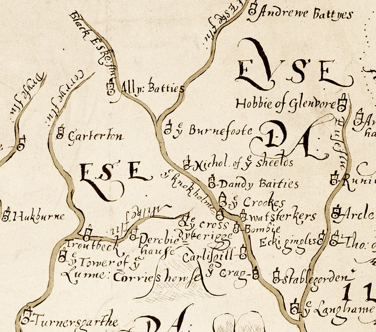
a location shown on a 1590 map of the West Marches of Scotland (The Aglionby Platt)

Also known as, or recorded in historical documents as; Langholm Tower; The Holm

In the civil parish of Langholm.
In the historic county of Dumfriesshire, Scotland.
Modern Authority of Dumfries And Galloway, Scotland.
1974 county of Dumfries and Galloway, Scotland.

OS Map Grid Reference: NY36178494
Latitude 55.15473° Longitude -3.00318°

This is certain as the location of ye Langhame shown on the Aglionby Platt.

There are masonry ruins/remnants remains.

This site is a scheduled monument protected by law.

The likely form(s) of this building in 1590 are;

  • Tower House (gentry).

A section of the 1590 Aglionby Platt. Image reproduced by permission of the National Library of Scotland
Reproduced by permission of the National Library of Scotland
Description

(NY 3617 8494) Langholm Castle (NR) (Remains of) (OS 6" map (1957))
Part of the S gable with its returns remains of Langholm Castle, a tower, measuring 42ft by 30ft, with was built possibly about 1526. There is no exact date for its final abandonment, probably about 1724. (RCAHMS 1920, visited 1912; J and R Hyslop 1912)
The extant remains of Langholm Castle comprise a 9.2m long, 6.0m high wall, with two short return walls which are 3.8m and 3.5m long respectively. There is a narrow rectangular window gap and, above it, a large hole which probably indicates the former position of a larger window.
This structure stands at the S end of a sub-rectangular platfrom which is 18.0m by 11.0m and up to 1.7m high; this is a turf-covered mound of rubble which is probably overlying buildings foundations.
There are linear scarps and depressions to the E and W of the platform and others in the surrounding area including a 1.5m high amorphous mound at NY 3619 8492. They have all been so extensively mutilated, probably by stone-robbing activities, that their origins and purposes cannot be deduced from the surface remains. Surveyed at 1/2500. Visited by OS (MJF) 27 September 1979.
All that remains of this tower are the S wall, standing to a height of 6m, and fragments of the E and W Walls. (RCAHMS 1981, visited March 1981)
(NY 361 849 and 365 855). The fragmentary tower 12.6m long by 9m wide near to the confluence of the Esk with the Ewes Water may be the tower betrayed to the English in 1544 and recaptured in 1547 by the Scottish Regent. The cellar of the smaller later tower survives in a wing of the Buccleuch Arms Hotel on the NE side of the town. Langholm was a Maxwell barony sold to Douglas of Drumlanrig by the 2nd Earl of Nithsdale. (M Salter 1993)
Badly ruined remains of a tower house built for the Armstrongs at the beginning of the 16th cent. and largely demolished in 1725. It has been a rubble-walled rectangle. A fair amount of the S gable survives; in it, a rectangular first-floor window. Stubs of the E and W walls. No evidence of vaulting inside. (J Gifford 1996)
Listed as Langholm, tower. (RCAHMS 1997)
This site was visited in the course of fieldwork by Dr. T.C. Welsh in 2003. For further information, see MS/1331
NY 3617 8494 A survey of the remains surrounding Langholm Castle (NY38SE 3) showed that the castle remains extend beyond the Scheduled area and occupy the whole space between the Esk and a former course of Ewes Water, passing within 50m N of the tower. Evaluation is complicated by the part-raised, part-excavated surface of a horse racing track surrounding the Scheduled area. In particular, building foundations were observed between the fence and racetrack on the S. The main additional feature is a substantial foundation, 19m by at least 20m NW-SE, with an axial division, possibly the base of an earlier tower. An L-shaped stone platform overlies its NW corner, and there appears to be a curved wall attached to the E side. There are also traces of a rectangular enclosure round the site formed by a bank and ditch on three sides against the Esk bank, 80m E-W by 70m. (T C Welsh 2004) (Canmore)

The monument comprises the fragmentary remains of Langholm Castle, a tower-house built for the Armstrongs in the early 16th century in a defensive position at the confluence of the River Esk and Ewes Water.
The above-ground structures consist of part of the S gable of a former rectangular tower and short sections of the adjoining E and W walls. The S wall stands to a height of 6m and incorporates a gun port and a window opening. The castle was largely demolished in 1725 and demolition rubble has accumulated in and around the ruined tower giving the impression that the walls now stand on a turf-covered mound. The rubble almost certainly overlies additional evidence for the castle's history as do the linear scarps and depressions which lie to the E and W of the mound and which doubtless indicate the site of ancillary buildings. To the SW of the mound, running parallel to the Ewes Water, can be discerned the faint traces of a bank and ditch.
The area to be scheduled is an irregular pentagon on plan, with maximum dimensions of 150m NW-SE by 160m E-W, to include the upstanding remains of the tower and an area around it within which the presence of several linear scarps and depressions indicates the existence of associated features. The boundary runs as follows: from its N-most point (which lies 40m ENE of the N corner of the fence which surrounds the castle) for 80m in a SE direction, then SW for 90m before turning WNW for 120m, then NNE for 70m before turning due E for 100m to return to the starting point; all as marked in red on the accompanying map extract. Excluded from the scheduling are the above-ground sections of the fence surrounding the castle and also the information board. (Scheduling Report)
Links to archaeological and architectural databases, mapping and other online resources

Data >
Canmore   County HER   Scheduling    
Maps >
Streetmap   NLS maps   Where's the path   Geology  
Air Photos > 
Bing Maps   Google Maps   Getmapping   Flashearth  
Photos >
Geograph   Flickr   Panoramio      

Sources of information, references and further reading
Most of the sites or buildings recorded in this web site are NOT open to the public and permission to visit a site must always be sought from the landowner or tenant.
It is an offence to disturb a Scheduled Monument without consent. It is a destruction of everyone's heritage to remove archaeological evidence from ANY site without proper recording and reporting.
Don't use metal detectors on historic sites without authorisation.
The information on this web page may be derived from information compiled by and/or copyright of Historic England, RCAHMS (or its successor Historic Environment Scotland), County Historic Environment Records and other individuals and organisations. All the sources given should be consulted to identify the original copyright holder and permission obtained from them before use of the information on this site for commercial purposes.
The author and compiler of Gatehouse does not receive any income from the site and funds it himself. The information within this site is provided freely for educational purposes only.
The bibliography owes much to various bibliographies produced by John Kenyon for the Council for British Archaeology, the Castle Studies Group and others.
Suggestions for finding online and/or hard copies of bibliographical sources can be seen at this link.
Minor archaeological investigations, such as watching brief reports, and some other 'grey' literature is most likely to be held by H.E.R.s but is often poorly referenced and is unlikely to be recorded here, or elsewhere, but some suggestions can be found here.
The possible site or monument is represented on maps as a point location. This is a guide only. It should be noted that OS grid references defines an area, not a point location. In practice this means the actual center of the site or monument may often, but not always, be to the North East of the point shown. Locations derived from OS grid references and from latitude longitiude may differ by a small distance.
Further information on mapping and location can be seen at this link.
Please help to make this as useful a resource as possible by contacting Gatehouse if you see errors, can add information or have suggestions for improvements in functality and design.
Help is acknowledged.
This record created on 02/08/2015 09:44:26; This record last updated on 17/09/2015 11:13:49

Home | Books | Links | Fortifications and Castles | Other Information | Help | Downloads | Author Information | Contact
¤¤¤¤¤