GATEHOUSE
The comprehensive gazetteer and bibliography of the medieval castles, fortifications and palaces of England, Wales, the Islands.
 
 
Home
The listings
Other Info
Books
Links
Downloads
Contact
 
Aglionby Platt Home
 
Print Page 
 
Next Record 
Previous Record 
Back to list 

The Gatehouse website record of

Sim s' Thoms (Side Tower)

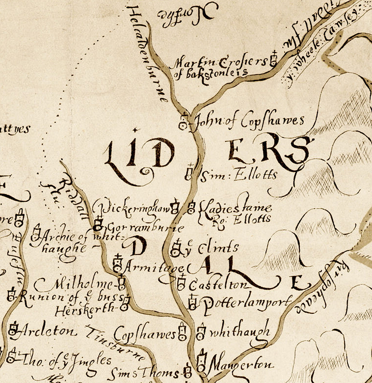
a location shown on a 1590 map of the West Marches of Scotland (The Aglionby Platt)

Also known as, or recorded in historical documents as; Syid; Kirk High

In the civil parish of Castleton.
In the historic county of Roxburghshire, Scotland.
Modern Authority of Scottish Borders, Scotland.
1974 county of Borders, Scotland.

OS Map Grid Reference: NY46338582
Latitude 55.16377° Longitude -2.84400°

The given map reference is suggested as the probable location of Sim s' Thoms shown on the Aglionby Platt.

There are no visible remains.

The likely form(s) of this building in 1590 are;

  • Unmortared Pele
    Pele House ('bastle').

A section of the 1590 Aglionby Platt. Image reproduced by permission of the National Library of Scotland
Reproduced by permission of the National Library of Scotland
Description

(NY 4633 8582) Side Tower (NR) (Site of) (OS 6" map (1957))
This spot was pointed out by two local informants in 1858 as the site of Side Tower, which belonged to the Armstrongs, and in which lived "Jock o' the Side", well known in Border Ballads. (Name Book 1858)
Jeffrey (1864) notes that the site is marked by a solitary ash tree and a few grass-grown mounds.
Armstrong refers to the house of Jock Armstrong of the Side, stating that no trace of it remains, though not far beyond living memory a score of tenanted houses stood here, forming the hamlet of Side. The foundations of these cottages are still plainly visible. (W A Armstrong 1960)
There is no evidence of this alleged tower and no trace of building foundationsin the indicated area. The hillslope is heavily mutilated by eroded river channels, drainage ditches and banks; the two amorphous, turf-covered stony mounds are at NY 4635 8583. Dr Robson (Hawick Museum) has no documentary record of a tower at Side and he says that Jock o' the Side's house was the Puddingburn Tower (NY48NE 5). Visited by OS (MJF) 20 August 1979
Nothing can be seen of a tower amongst the remains of this farmstead, which is situated on a terrace on a SE-facing hillside. The farmstead comprises at least three buildings, a kiln-barn and a complex of small enclosures, all overgrown with grass and rushes, at the centre of which there stands a disused circular sheep stell. To the W of the farmstead there are two substantial boundary ditches, each with fragments of an upcast bank on its inner (downhill) edge, which appear to represent successive phases of enclosure of the hillside. One of the ditches runs through the farmstead, which it appears to predate as two buildings (LID96 46-7) stand on the line of the upcast bank. The second ditch, farther up the hill to the NW, appears to represent an expansion of the enclosed ground to occupy the gap between the enclosures on Sufficient Hill, to the SW (NY48NE 144.00), and Kirk Hill, to the NE (NY48NE 145). The later ditch at Side abuts the boundaries of these other enclosures.
Within the area enclosed by these boundary ditches a system of subrectangular fields takes in about 6ha. The fields are defined by earthen banks and contain traces of rig cultivation with a 'reverse-S' form.
The largest of the farmstead buildings (LID96 46) measures 12.6m in length and splays from 3.8m in breadth at the SSE end to 4.5m on the NNW within a turf wall 0.5m high and spread to 1.3m in thickness. There may be the remains of an enclosure on its NE side and 20m to the E there is a large grass-grown mound that may be a midden heap. The other two buildings (LID96 47-8) are considerably smaller, measuring respectively 6.7m by 3.5m and 8.3m by 2.9m within walls constructed largely of turf and standing no more than 0.3m high. The kiln-barn (LID96 49) comprises a bowl set into the hillside on the NNW with the fragmentary remains of the barn on a platform on the uphill side. The bowl measures 2.5m in diameter and 0.5m in depth and a gap on the SSE indicates the position of the flue; the barn measures 4.2m by 3m within a stony bank 0.8m thick. Around the farmstead there are about ten small subrectangular enclosures, amongst which there may be fragments of other buildings. Two of the enclosures, at the S edge of the site, contain lazy-bed cultivation. (LID96 46-9) Visited by RCAHMS (SDB) 13 November 1996
A field-system marked by pecked lines is depicted on the 1st edition of the OS 6-inch map (Roxburghshire 1862-3, sheet xlv), but it is not shown on the current edition of the OS 1:10000 map (1982). Information from RCAHMS (SAH) 2 August 2000 (Canmore)
Comments

The 1590 map is not easy to interpret and can be inaccurate (sometime houses are placed on the wrong side of waterways). However I consider this is the site marked 'Sim s' Thoms;' on that map and the Jock Armstrong's house (marked as LardeJockes on the 1590 map) was Puddingburn 'Tower'.
The resident householder c. 1590.

Simon Thoms
Links to archaeological and architectural databases, mapping and other online resources

Data >
Canmore            
Maps >
Streetmap   NLS maps   Where's the path   Geology  
Air Photos > 
Bing Maps   Google Maps   Getmapping   Flashearth  
Photos >
Geograph   Flickr   Panoramio      

Sources of information, references and further reading
Most of the sites or buildings recorded in this web site are NOT open to the public and permission to visit a site must always be sought from the landowner or tenant.
It is an offence to disturb a Scheduled Monument without consent. It is a destruction of everyone's heritage to remove archaeological evidence from ANY site without proper recording and reporting.
Don't use metal detectors on historic sites without authorisation.
The information on this web page may be derived from information compiled by and/or copyright of Historic England, RCAHMS (or its successor Historic Environment Scotland), County Historic Environment Records and other individuals and organisations. All the sources given should be consulted to identify the original copyright holder and permission obtained from them before use of the information on this site for commercial purposes.
The author and compiler of Gatehouse does not receive any income from the site and funds it himself. The information within this site is provided freely for educational purposes only.
The bibliography owes much to various bibliographies produced by John Kenyon for the Council for British Archaeology, the Castle Studies Group and others.
Suggestions for finding online and/or hard copies of bibliographical sources can be seen at this link.
Minor archaeological investigations, such as watching brief reports, and some other 'grey' literature is most likely to be held by H.E.R.s but is often poorly referenced and is unlikely to be recorded here, or elsewhere, but some suggestions can be found here.
The possible site or monument is represented on maps as a point location. This is a guide only. It should be noted that OS grid references defines an area, not a point location. In practice this means the actual center of the site or monument may often, but not always, be to the North East of the point shown. Locations derived from OS grid references and from latitude longitiude may differ by a small distance.
Further information on mapping and location can be seen at this link.
Please help to make this as useful a resource as possible by contacting Gatehouse if you see errors, can add information or have suggestions for improvements in functality and design.
Help is acknowledged.
This record created on 22/07/2015 06:53:17; This record last updated on 17/09/2015 11:29:21

Home | Books | Links | Fortifications and Castles | Other Information | Help | Downloads | Author Information | Contact
¤¤¤¤¤