GATEHOUSE
The comprehensive gazetteer and bibliography of the medieval castles, fortifications and palaces of England, Wales, the Islands.
 
 
Home
The listings
Other Info
Books
Links
Downloads
Contact
 
Aglionby Platt Home
 
Print Page 
 
Next Record 
Previous Record 
Back to list 

The Gatehouse website record of

LardgJockes (Puddingburn Tower)

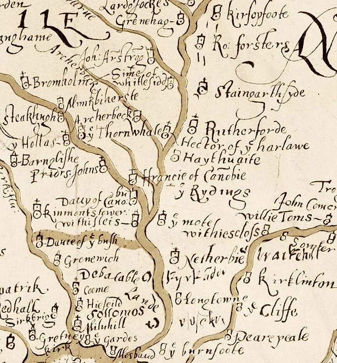
a location shown on a 1590 map of the West Marches of Scotland (The Aglionby Platt)

Also known as, or recorded in historical documents as; Puddingburn Ha; Stanygill Burn; Side; Bornemothe

In the civil parish of Castleton.
In the historic county of Roxburghshire, Scotland.
Modern Authority of Scottish Borders, Scotland.
1974 county of Borders, Scotland.

OS Map Grid Reference: NY45488578
Latitude 55.16333° Longitude -2.85725°

The given map reference is suggested as the probable location of LardgJockes shown on the Aglionby Platt.

There are masonry footings remains.

The likely form(s) of this building in 1590 are;

  • Pele House ('bastle')
    Unmortared Pele.

A section of the 1590 Aglionby Platt. Image reproduced by permission of the National Library of Scotland
Reproduced by permission of the National Library of Scotland
Description

(NY 4548 8577) Earthwork (NR) (OS 6" map (1957))
Old House, Stanygill Burn: On a narrow promontory between Black Grain and Dow Sike, at the point where they join Stanygill Burn, there is a sheepfold with two small, rectangular stone structures on its W side. The N and W walls of the more northerly of these show constructional features suggesting they once formed two sides of a small 16th century house. Jeffrey, mentioning a corner of wall "of great thickness and strength" still standing here, calls this "Puddingburn Ha'".
Close by, on the SE, the promontory is crossed by a low eastern bank, without ditch or entrance, which may be contemporary. (RCAHMS 1956, visited 1949; A Jeffrey 1864)
Armstrong mentions "Puddingburn Tower" near to Side (NY48NE 6). (W A Armstrong 1960)
The sheepfold is as described; the 1.2m wide walls contain numerous squared blocks but the supposed 16th century walling cannot be identified. Dr Robson (curator, Hawick Museum) is fairly sure that this is the site of Puddingburn Tower, however, this supposition cannot be verified from ground evidence. There is no trace of a bank on the SE side, however, there are many other sinuous field banks surrounding the sheepfold but none appear to have any special significance. Visited by OS (MJF) 17 August 1979.
The remains of this rectangular tower-house, situated on a promontory at the confluence of the Dow Sike with the Stanygill Burn, have been incorporated within a more recent sheep stell. The surviving portion of the tower wall measures 6.6m from N to S by 5m transversely, is 1.3m thick and stands to a maximum height of 1.5m. What may be the S end wall is marked by a low bank, but there is no trace of the E wall. A splayed window is visible in the N wall. To the SW of the tower there is a curving section of bank, 2.5m in thickness; its function is unknown. (LID96 319)
Visited by RCAHMS (JBS) 16 April 1996 (Canmore)
Comments

Classified as a "Tower House (medieval)(possible)" in Canmore but the description of the physical remains (which are scant) is of a pele-house type bastle. Appears to me to be the fortified house marked as LardeJockes on the 1590 map.
The resident householder c. 1590.

John Armestronge called "the Lairds Jocke" (Border Papers)
Links to archaeological and architectural databases, mapping and other online resources

Data >
Canmore            
Maps >
Streetmap   NLS maps   Where's the path   Geology  
Air Photos > 
Bing Maps   Google Maps   Getmapping   Flashearth  
Photos >
Geograph   Flickr   Panoramio      

Sources of information, references and further reading
Most of the sites or buildings recorded in this web site are NOT open to the public and permission to visit a site must always be sought from the landowner or tenant.
It is an offence to disturb a Scheduled Monument without consent. It is a destruction of everyone's heritage to remove archaeological evidence from ANY site without proper recording and reporting.
Don't use metal detectors on historic sites without authorisation.
The information on this web page may be derived from information compiled by and/or copyright of Historic England, RCAHMS (or its successor Historic Environment Scotland), County Historic Environment Records and other individuals and organisations. All the sources given should be consulted to identify the original copyright holder and permission obtained from them before use of the information on this site for commercial purposes.
The author and compiler of Gatehouse does not receive any income from the site and funds it himself. The information within this site is provided freely for educational purposes only.
The bibliography owes much to various bibliographies produced by John Kenyon for the Council for British Archaeology, the Castle Studies Group and others.
Suggestions for finding online and/or hard copies of bibliographical sources can be seen at this link.
Minor archaeological investigations, such as watching brief reports, and some other 'grey' literature is most likely to be held by H.E.R.s but is often poorly referenced and is unlikely to be recorded here, or elsewhere, but some suggestions can be found here.
The possible site or monument is represented on maps as a point location. This is a guide only. It should be noted that OS grid references defines an area, not a point location. In practice this means the actual center of the site or monument may often, but not always, be to the North East of the point shown. Locations derived from OS grid references and from latitude longitiude may differ by a small distance.
Further information on mapping and location can be seen at this link.
Please help to make this as useful a resource as possible by contacting Gatehouse if you see errors, can add information or have suggestions for improvements in functality and design.
Help is acknowledged.
This record created on 22/07/2015 06:51:02; This record last updated on 17/09/2015 11:28:33

Home | Books | Links | Fortifications and Castles | Other Information | Help | Downloads | Author Information | Contact
¤¤¤¤¤