GATEHOUSE
The comprehensive gazetteer and bibliography of the medieval castles, fortifications and palaces of England, Wales, the Islands.
 
 
Home
The listings
Other Info
Books
Links
Downloads
Contact
 
Aglionby Platt Home
 
Print Page 
 
Next Record 
Previous Record 
Back to list 

The Gatehouse website record of

Dunfreise (Dumfries)

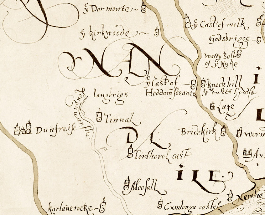
a location shown on a 1590 map of the West Marches of Scotland (The Aglionby Platt)

Also known as, or recorded in historical documents as; Maxwell's Castle

In the civil parish of Dumfries.
In the historic county of Dumfriesshire, Scotland.
Modern Authority of Dumfries And Galloway, Scotland.
1974 county of Dumfries and Galloway, Scotland.

OS Map Grid Reference: NX97127629
Latitude 55.07042° Longitude -3.61260°

The given map reference is suggested as the probable location of Dunfreise shown on the Aglionby Platt.

There are no visible remains.

The likely form(s) of this building in 1590 are;

  • Other
    Tower House (baronial).

A section of the 1590 Aglionby Platt. Image reproduced by permission of the National Library of Scotland
Reproduced by permission of the National Library of Scotland
Description

(NX 9712 7629) Site of Dumfries Castle (NR) OS 1:1056 map (1852)
The battlemented town house of the Maxwells at Dumfries, which was built about 1545, is often referred to as the second castle of Dumfries (cf NX97SE 2). It is said to have been 'of three storeys, with four large vaults in the basements, and a turnpike stair and bartizan covered with lead; and there were four or five acres of ground attached to it and walled in'. It was in need of repair when troops were garrisoned there in 1675, and in 1724 the New Church was built on the site. (J Barbour 1890; 1907)
Stone from the Greyfriars Friary (NX97NE 13) was alleged to have been used in the repair of Maxwell of Caerlaverock's 'castle' after 1570. (SBS Dumfries 1977; W McDowell 1867)
Four heraldic panels, reputed to have come from the 16th century town-house of the Maxwell family, which stood on the site of the modern Greyfriars Church, are built into rockeries in the garden of a villa, St Christopher's in St Mary Street. They were part of the collection of the late James Barbour. (RCAHMS 1920, visited 1915)
A collection of very ancient clay pipe-heads found while excavating Site of Greyfriars's church (1868) on site of Dumfries Castle. Supposed to have been smoked by soldiers of garrison of that castle about 300 years ago. Some material in the head of one was analysed and found to be a sort of lint, so evidently it had been before Sir W. Raleigh introduced the Weed. (R Gibson, Antiquarian, Dumfries) (J Williams 1975) (Canmore 65538)

(NX 9775 7467) Castle(NR) (site of) OS 6" map (1970)
A royal castle was established on the motte at Castledykes. It was rebuilt in stone in the 1260's and during the Edwardian occupation, a great ditch was dug around the castle, which was also encircled by a wooden paling. There is a strong belief that this castle was destroyed after its capture by Bruce in 1313 and was not rebuilt. (SBS Dumfries 1977)
The RCAHMS state that it is not now possible to determine the layout of the castle due to landscaping, but describe the oblong mound SE of Castledykes mansion as the remains of a motte, where remains of a ditch and rampart may be seen round its E and S sides; the associated bailey probably extended W towards the river. Small scale excavations here in 1953 revealed traces of walling, just SW of, and also N of the flagstaff (see NX97SE 2.1.) Some 20 pieces of pottery, mainly 13th / 14th century in date, were recovered and are now in Dumfries Museum.
(This castle is erroneously named "Comyn's Castle" on earlier editions of the OS maps.) (RCAHMS 1920), visited 1915; A E Truckell 1955; A E Truckell and J Williams 1967; J Williams 1968. (Canmore 65688)
Comments

The 1590 map probably shows the town, which was not walled, rather than the defunct royal castle south of the town at Castledykes. However the large tower house of the Maxwells was a significant fortified building and the map may be referring to this.
Links to archaeological and architectural databases, mapping and other online resources

Data >
Canmore   County HER        
Maps >
Streetmap   NLS maps   Where's the path   Geology  
Air Photos > 
Bing Maps   Google Maps   Getmapping   Flashearth  
Photos >
Geograph   Flickr   Panoramio      

Sources of information, references and further reading
Most of the sites or buildings recorded in this web site are NOT open to the public and permission to visit a site must always be sought from the landowner or tenant.
It is an offence to disturb a Scheduled Monument without consent. It is a destruction of everyone's heritage to remove archaeological evidence from ANY site without proper recording and reporting.
Don't use metal detectors on historic sites without authorisation.
The information on this web page may be derived from information compiled by and/or copyright of Historic England, RCAHMS (or its successor Historic Environment Scotland), County Historic Environment Records and other individuals and organisations. All the sources given should be consulted to identify the original copyright holder and permission obtained from them before use of the information on this site for commercial purposes.
The author and compiler of Gatehouse does not receive any income from the site and funds it himself. The information within this site is provided freely for educational purposes only.
The bibliography owes much to various bibliographies produced by John Kenyon for the Council for British Archaeology, the Castle Studies Group and others.
Suggestions for finding online and/or hard copies of bibliographical sources can be seen at this link.
Minor archaeological investigations, such as watching brief reports, and some other 'grey' literature is most likely to be held by H.E.R.s but is often poorly referenced and is unlikely to be recorded here, or elsewhere, but some suggestions can be found here.
The possible site or monument is represented on maps as a point location. This is a guide only. It should be noted that OS grid references defines an area, not a point location. In practice this means the actual center of the site or monument may often, but not always, be to the North East of the point shown. Locations derived from OS grid references and from latitude longitiude may differ by a small distance.
Further information on mapping and location can be seen at this link.
Please help to make this as useful a resource as possible by contacting Gatehouse if you see errors, can add information or have suggestions for improvements in functality and design.
Help is acknowledged.
This record created on 02/08/2015 09:03:09; This record last updated on 22/09/2015 09:16:11

Home | Books | Links | Fortifications and Castles | Other Information | Help | Downloads | Author Information | Contact
¤¤¤¤¤